Mount Sanitas Trail
The Mount Sanitas Trail is a steep, rocky hike on the west edge of Boulder, Colorado, that climbs 1,323 feet over 1.3 miles to an open summit with wide views of the city and the foothills, with a popular loop of about 3.3 miles round trip.
Outdoor Boulder › Destinations › Mount Sanitas
Mount Sanitas quick facts
- Distance
- About 3.3 miles round trip for the standard loop. City of Boulder Open Space and Mountain Parks (OSMP) lists the Mount Sanitas Trail at 1.3 miles one way to the summit.
- Elevation gain
- 1,323 feet (OSMP, Mount Sanitas Trail)
- Difficulty
- Hard. A steep, rocky, stair-stepped climb.
- Dog policy
- Dogs allowed. On a hand-held leash at all times unless they have a City of Boulder Voice and Sight tag. Dogs must be leashed at the trailhead.
- Fee
- Free. No parking fee at the Centennial Trailhead.
- Parking
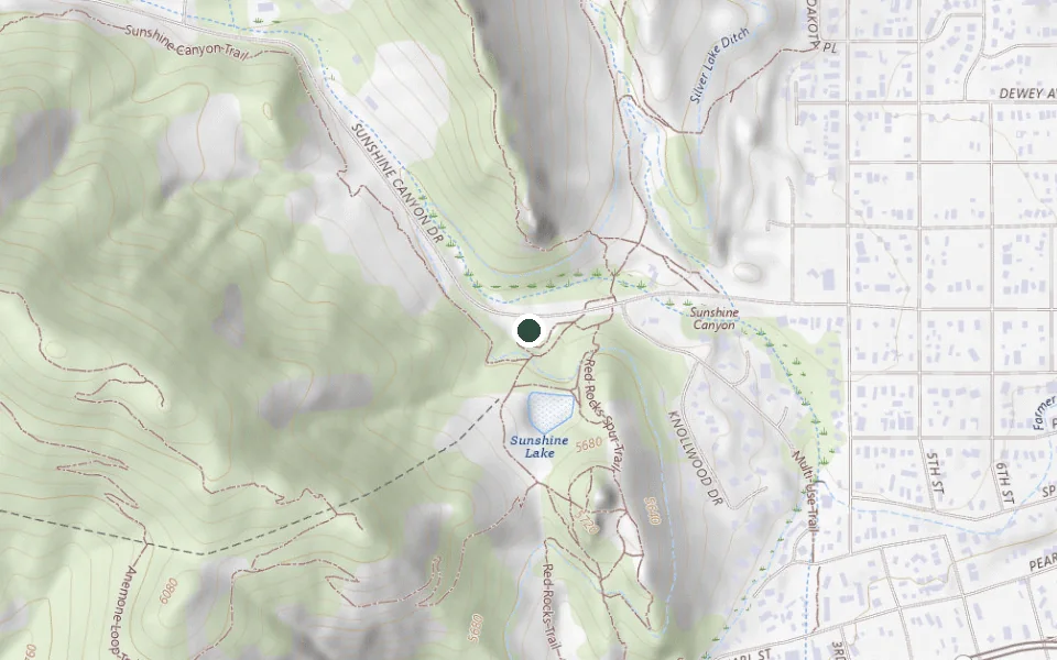
- Centennial Trailhead, south side of Sunshine Canyon Drive: 31 standard spaces plus 2 ADA spaces. It fills early on weekends.
- Best season
- Spring through fall. Start early to beat afternoon storms and heat; the west-facing rock holds sun.
Mount Sanitas snapshot
- Trail type
- Loop. Most people climb the Mount Sanitas Trail, come down the East Ridge Trail and walk back along Sanitas Valley, about 3.3 miles round trip. Taken on its own, the summit climb is an out-and-back.
- Time on trail
About 1 hour 45 minutes to 2 hours 45 minutes.Our estimate
Our own arithmetic, not an agency figure. OSMP publishes no hiking time, so we work from the 3.3 miles and 1,323 feet of gain on this page using Naismith's rule (one hour per 3 miles, plus one hour per 2,000 feet of climb), then add half again at the top end for stops, rock steps and altitude.
- Drive time
From downtown BoulderAbout 5 minutes, a mile, from the Pearl Street Mall.
From downtown DenverAbout 45 minutes, 29 miles, from downtown Denver.
Approximate, from road routing in free-flowing traffic. The drive is never the problem here; the 33-space lot is.
- Restrooms and water
RestroomsAt the trailhead, along with four picnic tables, plus three more tables and a small pavilion across the street at the Sanitas access (OSMP).
Drinking waterNot published. OSMP lists no drinking water at Centennial, so fill up before you leave town.
- How busy it gets
OSMP rates Centennial high use: more than 200 average visits a day, into a lot of 31 standard spaces and 2 ADA spaces.
City of Boulder OSMP, Centennial Trailhead. OSMP publishes no breakdown by day or hour, so we don't give one.
Trail type, restrooms and crowd figures on this page come from the managing agency. Time on trail and drive time are our own arithmetic, labeled as estimates, because no agency publishes them. Where an agency publishes nothing, this block says so instead of borrowing a number from somewhere else.
The trail at a glance
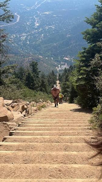
Mount Sanitas is the climb locals reach for when they want a hard workout close to town. The Mount Sanitas Trail runs up the ridge on the west side, and it earns its "hard" rating fast: the route is a near-constant staircase of rock steps and boulders, with a bit of hands-on scrambling near the top. OSMP puts the gain at 1,323 feet over 1.3 miles to the summit, so you're going up the whole way.
The summit opens onto wide views of Boulder, the plains to the east, and the higher foothills to the west. Most people come down the gentler East Ridge Trail and return on the flat Sanitas Valley Trail, which makes a loop of about 3.3 miles. If you'd rather not climb the stairs at all, the Sanitas Valley Trail alone is a mellow out-and-back along the valley floor.
Mount Sanitas parking and trailhead
You'll park at the Centennial Trailhead on the south side of Sunshine Canyon Drive, just west of the Sanitas access point, about a mile from downtown. It has 31 standard spaces plus 2 ADA spaces, a restroom, and picnic tables, and there's no parking fee. The lot is small for how popular the trail is, so it fills early on weekend mornings. If it's full, the SKIP, 208, and Y bus routes stop at Broadway and Mapleton, a walk or bike ride west to the trailhead.
Which way to hike the loop
Most locals go up the steep Mount Sanitas Trail first, while their legs are fresh, then descend the East Ridge Trail and stroll back on Sanitas Valley. Going up the stairs is honest work but it's more stable than coming down them. You can run the loop the other way to save the hardest climbing for a warmed-up finish, but the East Ridge ascent is longer and less scenic.
Hiking Mount Sanitas with dogs
Dogs are welcome. They have to be on a hand-held leash at all times unless they wear a City of Boulder Voice and Sight tag, and they must be leashed in the trailhead area no matter what. It's a fine dog hike, but the rock steps are hard on paws and the exposed rock gets hot in summer, so bring water for the dog too and skip the midday heat.
What to bring and when to go
Boulder sits high and dry, so carry more water than you think you'll need, wear real shoes with grip for the rock, and pack a layer. Afternoon thunderstorms build fast in summer, and you don't want to be on the open summit when they do, so start early. Spring through fall is prime; winter leaves ice and packed snow on the shaded upper steps.
Nearby trails and guides
- Royal Arch Trail: another steep, iconic Boulder climb, this one to a natural stone arch.
- Boulder Falls: a short, easy waterfall stop for a lighter day (currently closed for rockfall repairs).
- Walker Ranch: a rugged foothills loop southwest of town.
- All hikes in Boulder: the full hiking hub, sorted by difficulty.
Mount Sanitas FAQ
How long is the Mount Sanitas trail?
The Mount Sanitas Trail climbs 1.3 miles one way to the summit, and the popular loop back down the East Ridge and Sanitas Valley trails runs about 3.3 miles round trip. No agency publishes a hiking time; working from that distance and gain, we estimate about 1 hour 45 minutes to 2 hours 45 minutes.
How hard is Mount Sanitas?
OSMP rates it hard. It's a steep, sustained climb with rock steps and stairs most of the way up, and some scrambling near the summit. The gain is 1,323 feet in a short distance.
Can you bring dogs on Mount Sanitas?
Yes. Dogs are allowed but must be on a hand-held leash at all times unless they wear a City of Boulder Voice and Sight tag, and they must be leashed at the trailhead. You have to pick up and pack out waste.
Where do you park for Mount Sanitas?
Park at the Centennial Trailhead on the south side of Sunshine Canyon Drive, just west of the Sanitas access point. It has 31 standard spaces and 2 ADA spaces, and it fills early on weekend mornings.
Is there a fee to hike Mount Sanitas?
No. There's no parking fee at the Centennial Trailhead and no charge to hike the trail.
Sources
Trail facts on this page are drawn from these authoritative sources:
Last checked .